MayBe
18 Islands
Over the Rainbow
Come Rain or Shine
Faroes
This kind of elevenie pretty much describes my perception of the Faroe Islands. They are located in the Northern Atlantic more or less halfway between Shetland and Iceland. One can go to the group of 18 major islands (of a total of 779 islands, islets and skerries according to Wikipedia) by plane or by ferry.
MS Norröna connects the Faroes with Hirtshals at the northern tip of Denmark and Seyðisfjörður at the eastern coast of Iceland.


Skansin Lighthouse leads the way to Tórshavn, the capital and largest city of the Faroes. Tinganes was the first time meeting place of the parliament. Old and refurbished buildings shape the image of the historic centre. The open air museum at the outskirts of Tórshavn provides access to the inner of a translocated wealthy farmer’s house.
Tórshavn Cathedral (or Dómkirkjan) right above the harbour is the second oldest church of the Faroes. Vesturkirkjan (40,9 m) from 1975 is the highest building of the Faroe Islands.
")


")
")
")
")
")
")
The largest medieval building on the Faroes is Magnus Cathedral. It’s ruins rise in Kirkjubøur, across the hill in walking distance from Tórshavn. Kirkjubøargarður, the largest and oldest farmhouse on the Faroes is located right in front of the ruins. The oldest church – Saint Olav’s Church – rests beside Magnus Cathedral. It also dates back to the middle ages.
")
")
")


")
")
")

To me the rainbow is the connecting element on the Faroe Islands. It spans over the pass road leading north from Tórshavn. Arriving in Kaldbak and later Kollafjørður the sun shines again on examples of typical wooden Faroese churches with grass sod roofs.
")
")


A white church receives the ferry from Tórshavn at the harbour of Nolsoy at the northern end of the equally named island. A well marked path leads to Nólsoy Fyr at the southern shore.


Sailing, fishing and whaling has a tradition on the Faroe Islands. The former whaling station in Við Áir at the sound between Streymoy and Eysturoy is preserved as museum and can be visited.

")
")
")

In Haldórsvík a modern memorial reminds of all the seafarers who lost their lives at sea. The octagonal stone church at the same village is the only one of it’s kind on the Faroe Islands.
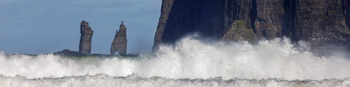
Tjørnuvík at the northern end of Streymoy island provides views of Risin og Kellingin sea stacks across the Sundini strait.
")


 and Kellingin (69 m), Tjørnuvík view")
An old path leads over the mountain from Tjørnuvík to Saksun. This has also been used to transport the disassembled elements of Tjørnuvík’s old church to the sand blocked Atlantic inlet for reconstruction. An open air museum has been implemented, too. Friendly signs ask the many visiting tourists to keep off the grass providing feed for the grazing sheep.
The church in Hvalvík from 1829 is the oldest of the typical Faroese wood churches with grass sod roofs. Beside the church trees have been planted in 1953 now constituting one of the smallest forests on the Faroes.
")

")

Heavy rain locked me in into my apartment in Hósvík.
In an instant the water falls down 140 m at Fossurin í Fossá, one of the highest waterfalls in the Faroe Islands.

 - one of the highest waterfalls in the Faroe Islands")
")
")
Rain – collected in reservoirs – provides almost 80% of the electrical energy of the Faroe Islands produced in Vestmanna.
")
")
")

Weather changes rapidly – now totally covering scenery and then revealing impressive rock formations.
Strong winds blow away Múlafossur at Gásadalur on the northern end of Vágar island.


")
")
")


")
Renovation works take place at the church in Bøur whilst the church in Sandavágur looks as if recently refurbished. It houses the here discovered runestone “Sandavágssteinurin”. I couldn’t manage to see it since Faroese churches usually are closed.
A sculpture in front of the church reminds of the Shepherd of Sondum legend.
In Kvívík one of the typical Faroese memorials reminds of the seafarers who lost their lives at sea.
The church in Kvívík from 1903 is located directly at the river Storá. Storá serves as a lifeline since long passed times. Kvívík is one of the oldest settlements in the Faroes. Foundations of Norsemen longhouses were found during construction activities and excavated since 1941. They are publicly accessible.
Studies of modern dome houses come into view driving the main road above and around Kvívík. Grønlendingahúsið (Greenlandic house) in Tórshavn demonstrates a larger sized implementation of the underlying architecture.
")
")
")
")
")

")

Sørvágsvatn or Leitisvatn (about 3,5 km²) on Vágar island is the largest lake in the Faroe Islands.
Nykurin presenting itself to humans as a horse rises above the water surface.
History tells from cliff Trælanípa (148 m) Irish slaves no longer fit for work were thrown to death into the Atlantic.

 at Sørvágsvatn")

")
")


At it’s southern banks Bøsdalafossur waterfall drains the also called “lake above the ocean”. From a height of about 30 m the water falls down to see level into the Atlantic.
 - Sørvágsvatn feeding the Atlantic")
 - Sørvágsvatn feeding the Atlantic")


As far as height is concerned Eysturoy island provides the deepest contrasts.
In Eiði (at Sundini opposite Tjørnuvík) with it’s central church and well maintained football field (being a real green) one enters the pass road to cross Eysturoy vertically. During winter or at bad weather conditions the pass road is closed. From the saddle of the pass it’s an easy climb up to Slættaratindur (880 m), Faeroe Islands’ highest mountain.
The deep gorge at Gjógv provides shelter for fisher boats as a natural harbour. If waves still find their way into the harbour the boats can be winched up high onto the cliffs. Rails support the steep slipway.
As in almost every Faeroese settlement a memorial reminds of all seafarers not having reached a safe harbour in time.


 view")
 view")


")
")
")
Elduvík features a natural harbour in a gorge and a seafarers’ memorial, too.
A sign indicates “It is not allowed to take stones/rocks” from the rocky beach.

")
")
")
")
")
According to local explanations “Grímur Kamban is said to be the first settler on Faroese Islands. He came here about the year 825, and it has always been the belief among the Faroese that he disembarked at Funningur.”

")
")
")
")

Fuglafjørður is highlighted by a rainbow.
At Toftanes in Leirvík remains of an ancient Nordic settlement were found and excavated in 1982-1987. Leirvík may be one of the oldest villages in the Faroes.
Leirvík Lighthouse leads the way through the sheltered sound between Eysturoy and the Northern Isles.
")
")
")

Klaksvík is the second largest city of the Faroe Islands and the central hub to the Northern Isles.
Klakkur mountain (413 m) provides the best view of total Klaksvík.
Viðarlundin úti í Grøv is implemented as a recreation area by planting trees since 1980.
Modern Christianskirkjan was completed in 1963.
From the roof of Christianskirkjan hangs an original “áttamannafar“ (specific Faroese eight person boat). In 1913 it’s whole crew drowned while fishing.
 view")
 hike - foggy summit")
 hike - foggy summit")


")
")
 at Christianskirkjan's rooftop (Klaksvík)")
Kunoyartunnilin (built in 1988) connects Kunoy with Klaksvík.
In 2024 21 tunnels are in operation linking islands together under the sea. The oldest one dates from 1961. Single lane roads with passing places lead through theses old pitch black tunnels. The newer ones house illuminated double lane roads. Blue and green light installations mark the middle of the tunnel at the deepest point.
Eysturoyartunnilin (from 2020) with three entrances even contains a roundabout decorated with sculpted metal sheets resembling the Faroese ring dance. One also can listen to a sound installation by tuning the radio to the right frequency while passing the tunnel.
New tunnels are still under construction adding to the existing ones or replacing them.
")
")
 roundabout")
 roundabout")
")
")
Klaksvík has a long fishing tradition. At nearby Haraldssund, close to Klaksvíks northern harbour, a modern fish factory has been built “into” the mountain.
From Hvannasund MS Ritan connects with the Northern Isles on the old postship route – there are no causeways, bridges or tunnels.
Viðareiði on Viðoy island is the northernmost settlement in the Faroe Islands. Malinsfjall (751 m) rises above the church to the south.


It is a 20 minutes sailing from Klaksvík to Kalsoy island. Having been the location of a James Bond movie it attracts crowds of visitors. Exposed Kallur Lighthouse provides breathtaking (taken literally remembering the very strong winds up on the ridges) views of the surrounding land- and seascape.
")
")
")
")
")

 and Risin (71 m) in front of Eysturoy")


 and Risin (71 m) in front of Eysturoy")
On my way back to Tórshavn I walked along the Toftavatn (of course under a rainbow) from Runavík to Toftir.
Fans of football surely will know Svangaskarð football stadium. Short dated it has been built in 1991 by blasting away the cup of a hill. Just to comply with FIFA and UEFA rules.


A 32 h sailing with Norröna, passing Shetland, under rainbows, brought me back from the Faroe Islands to the continent.
")

